Maps in hunting knowledge transfer
Knowledge transfer in hunting is a useful case to study for noticing how knowledge of different forms can be most easily shared with others. This series of posts carves unmarked ‘knowledge’ from tacit knowledge1, and from what I’ll call context-bound knowledge. Context-bound knowledge is best transmitted through physical experience, but when physical experience is costly or time-bound, groups use techniques (maps, storytelling) to help pregame the physical experience and to drive concepts home afterward.
One of the most useful techniques for sharing context-bound knowledge is the map.
Maps, Topographic Quadrangles
The US Geological Survey produces and provides topographical maps organized into strict grids, called quadrangles or quads. These quads2 are (in the modern era) fairly faithful representations of the elevation of a landscape, displayed as contour lines. Most hunting shacks will have their quad tacked on the wall.
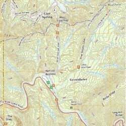
Unfortunately, these 1:24,000-scale maps are not detailed enough to scheme out one’s hunt, Dungeons and Dragons style. They won’t let someone unfamiliar with your land see “where they should stand.” They’re good enough for reference.
At Steve’s cabin, they put an X on the map each place they get a deer over the years. On the one hand, that lets you develop a little more rigor, ‘where are we getting deer year after year?’ On the other hand, if you keep going to the collection of X’s, you’re going to keep seeing deer at the X’s, and you won’t find out you’ve got deer somewhere else.
-my dad, independently describing a kind of sampling bias3
Quads are useful for tracking locations from year to year, and for refreshing the memories of people familiar but not intimate with the land.
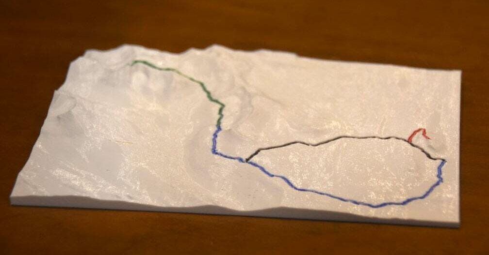
Maps, 3D Printed
Ideal hunting sites take advantage of local landforms—like overlooking a funnel point where several deer paths converge to skirt a lake. A helpful visualization for funnel points is a 3d-printed map. This is substantively the same information that’s displayed in the quad, but in a format you can run your fingers over. You can print your own by fetching a National Elevation Dataset 10 Meter from the USDA Geospatial Data Gateway and following a tutorial. The 10-meter dataset is still too low resolution to draw individual hunters’ paths, but shining a lamp from the southern edge can show younger hunters clearly “where’s a sunny hillside where a deer might like to bed? Where can she get a nice view while the sun warms her hide?”
Maps, Hand Drawn
Most useful for highlighting detail that isn’t visible at the scale of produced maps, and for naming important landmarks that may or may not be part of the landscape, is the hand-drawn map. “Where the bees used to be” is a great verbal instruction for people who hunted when a beekeeper used to let his hives forage on your wildflowers after strawberry blossom… but that was 15 years ago, and your younger cousin needs a cheat-sheet to know “right here, in this pine alley is what Patriarch means when he says “where the bees used to be”.
These maps usually won’t make sense to an outsider. Roads, treelines, and hills are drawn in the same linetype. Some roads get a line on each shoulder, other roads get a single line. “What is a useful landmark” is personally variable—if you asked each hunting party member to draw a map of the same drive, everybody’s map would include “dummy knob,” “concrete,” and “where the bees used to be” because in-hunt directions are given in reference to these shared landmarks. But “barbed wire,” “popple line” are personal landmarks, helping the map-drawer find her place in the territory. There is no guarantee these landmarks appear in other hunters’ sketches, or even in the same hunter’s sketch from year to year.
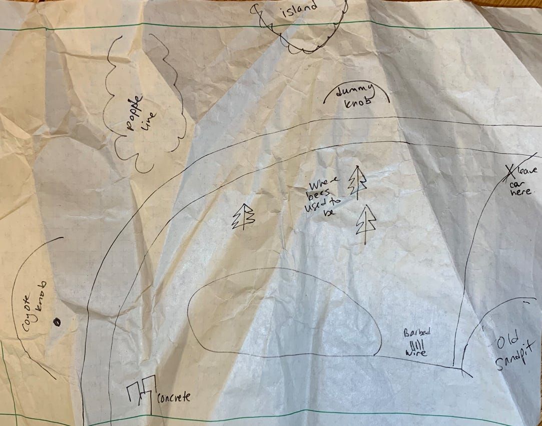
Despite inconsistencies and warped scales, hand-drawn maps give the most directly useful information for communicating “where we’re gonna start” and “where we’re gonna finish”.
The context-bound knowledge is highlighted here. Almost half of the pen strokes will be locative for instructions. (“Fritz posts on the dummy knob. Alice goes in at the concrete, and drives to where the bees used to be.”) More than with publicly generated maps, plans can be made and shared on hand-drawn maps. You can draw in your route, and mark where your sister will stand.
Future Tech
I look forward to a future of high resolution quads, which will enable the simple act of ‘drawing your own landmarks on an accurate contour map.’ 3D printing a tabletop map will allow hunters to rehearse routes when it’s cold, rainy, or not gun season yet.
Until that tech makes it into hunters’ hands, maps in the described formats have gotten the job of sharing context-bound knowledge done. We’ve been showing up in more or less the right place at more or less the right time, and filling up the freezers for generations.
Tacit knowledge is knowledge that can’t properly be transmitted via verbal or written instruction, like the ability to create great art or assess a startup. This tacit knowledge is a form of intellectual dark matter. Examples include woodworking, metalworking, housekeeping, cooking, dancing, amateur public speaking, assembly line oversight, rapid problem-solving, and heart surgery. Before video became available at scale, tacit knowledge had to be transmitted in person, so that the learner could closely observe the knowledge in action and learn in real time — skilled metalworking, for example, is impossible to teach from a textbook. Because of this intensely local nature, it presents a uniquely strong succession problem: if a master woodworker fails to transmit his tacit knowledge to the few apprentices in his shop, the knowledge is lost forever, even if he’s written books about it.↩︎
https://www.usgs.gov/faqs/how-do-i-find-download-or-order-topographic-maps↩︎
Ok, incredible, but the rats don’t seem to have a label for this one yet? Or maybe that it’s three mixed. Responses: “Not sure it has a name, but the problem is that the map of Xs throws away information about where you tried to get a deer and didn’t. Maybe keep two maps?” “exploration vs. exploitation tradeoff, related to the many-armed bandit problem” “Might be another name but I’d call it “getting stuck on a local optimum”: I think simulated annealing algorithms solve this by having several random starting points that they hillclimb/local optimize from. Which would be like if Steve, Alice, Joe, Fritz, and Jill all had their own X’d-up quads, and then compared their hauls after a few years. - Suspended Reason↩︎